Select Page
Timothy R. Nelson, Ph.D.
Senior Scientist

Timothy R. Nelson, Ph.D.

Senior Scientist

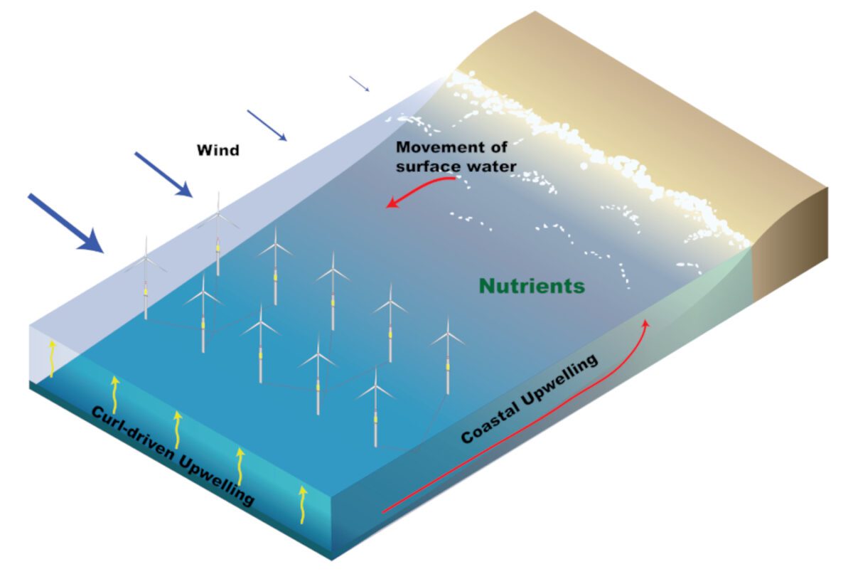
Dr. Timothy Nelson is an oceanographer with 10 years of experience researching hydrodynamics, sediment dynamics, and coastal geomorphology. His efforts have focused on quantifying the temporal and spatial evolution of benthic habitat, sediment resuspension, nearbed turbulence, and flooding. Dr. Nelson’s expertise includes geospatial and temporal data processing and analysis tasks related to hydrodynamics, sediment fate and transport, and acoustic effects on marine species. Dr. Nelson’s research has also focused on coastal response, recovery, and resiliency to abrupt changes in morphology, and the development of automated routines to quantify long-term shoreline change.


Hydrodynamics

Terminal Sedimentation Analysis, Vallejo, California Applied sedimentation rates derived from bathymetric surveys to hydrodynamic model simulations to inform the engineering design team on potential site response due to proposed pier reconfigurations.
Marina Sedimentation Analysis, Vallejo, California Assisted with the development of numerical models to study changes to sedimentation rates and dredging frequency due to reconfiguration of the marina. Applied sedimentation rates derived from bathymetric surveys to hydrodynamic model simulations to inform the engineering design team on potential site response.
Facility Flooding Analysis, Half Moon Bay, California Evaluated hydrodynamic model simulation of flooding due to riverine discharge and coastal inundation. Results helped inform adaptation strategies to mitigate future flooding at the facility.
River and Wetland Flooding due to Canal Breach, Colorado Developed a 2-dimensional HEC-RAS model to simulate a canal breach during a storm event that resulted in discharge down a steep mountain terrain. Analysis of flood extent and sediment fate and transport assisted with litigation efforts.
Sediment Cap Hydrodynamic Modeling, Confidential Site Utilized a 1-dimensional HEC-RAS model to determine change in river hydrodynamics due to placement of a sediment cap over potentially contaminated sediment.

Sediment Transport Modeling

Temporal and Spatial Benthic Boundary Layer Evolution, South Carolina and Georgia Developed spatial and temporal models to predict bedform evolution, associated turbulence, sediment resuspension, and sediment flux. Analyzed existing published bedform geometries and bedforms from field experiments to develop an equilibrium ripple prediction model that improves predictions compared to existing models. Using seabed sector scanning sonar, developed metrics to quantify ripple shape as a function of variations in ripple length and orientation. Using time series of ripple geometries, further developed a time-dependent model that predicts instantaneous non-equilibrium ripple geometry and orientation under waves and currents.
Low-Density, Centimeter-Scale Sediment Motion, Northern Gulf of Mexico This work focused on improving sediment transport formulations for centimeter-scale low-density agglomerates. This research arose out of a necessity to understand the transport and fate of sand and oil agglomerates (SOAs) that formed along the northern Gulf of Mexico following the Deepwater Horizon accident and oil spill. Because SOAs have a lower density than quartz, a variety of shapes, and large size compared to surrounding sediment, existing sediment transport formulations do not adequately predict their mobility. Conducted research that led to the development of a semi-empirical formulation that predicts incipient motion threshold for SOAs of various sizes and shapes. This was accomplished through laboratory experiments using artificial SOAs with embedded inertial measurement units, 3D-printed SOAs, and computer vision tracking. The results of this work can be applied to existing sediment transport prediction for mixed-grain coral reefs, and to the transport of marine debris, munitions, and other insoluble contaminants.

Coastal Geomorphology

Coastal Morphometric Analysis CMAT, South Padre Island, Texas Performed analysis and calculation of beach profile morphometrics from survey data. These results were incorporated into the Coastal Morphometrics Analysis Toolkit (CMAT) dashboard for the client.
Quantifying Barrier Island Storm Recovery and Resiliency, Fire Island, New York Conducting ongoing research focused on the collection and analysis of barrier island shoreline, shoreface, beach, and breach topography and bathymetry to determine the resiliency and evolution of barrier islands following tropical and extratropical storms. Utilizing bathymetry, GPS shoreline surveys, airborne imagery, and satellite-derived shorelines, developed metrics to describe breach evolution that demonstrate the importance of geology in breach migration and spit development in channel stability. The metrics were used to develop a hybrid Delft 3-dimensional XBeach geomorphic numerical model of breach evolution to identify processes controlling breach development and their influence on surrounding shoreline erosion and bay water levels. Satellite-derived shorelines were used to show the temporal and spatial extent of downdrift shoreline erosion following breach formation.

Renewable Energy

Marine Renewable Energy Support, Sandia National Laboratories (SNL) Supporting the development of a QGIS Python plugin for the Spatial Environmental Analysis Toolkit (SEAT). The goal of this effort is to improve performance, lower costs, and accelerate the deployment of marine and hydrokinetic energy technologies. Developed routines for analysis of benthic habitat changes, larval transport impacts, acoustic effects, and power generation potential. Assisted in the development of numerical models and workshop tutorial documentation for SEAT using the SNL-Delft 3-dimensional current energy conversion module.
Evaluation of Marine Species Acoustic Exposure for Offshore Wind Turbine Construction, Mid-Atlantic Bight Assisted with the development of analytical routines and data analysis to determine number of marine species affected by offshore wind turbine construction. Results are used for the development of the construction and operations plan.
Offshore Wind and Upwelling, California Energy Commission, California Assisted with the analysis of an atmosphere-ocean modeling effort to understand hydrodynamic changes by floating offshore wind turbines.
RETURN TO OUR TEAM PAGE